GPS Camera 55. Field Survey 4.0
Free Version
Publisher Description


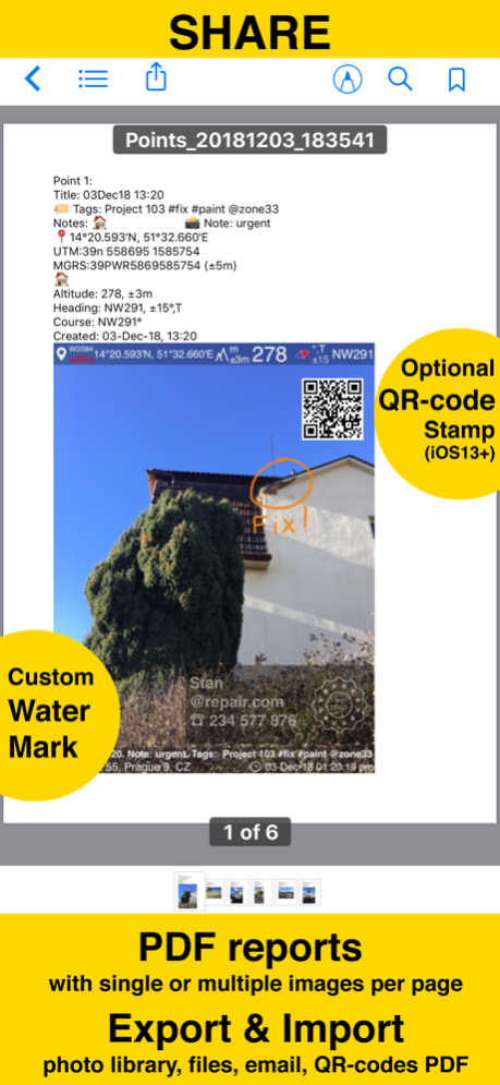
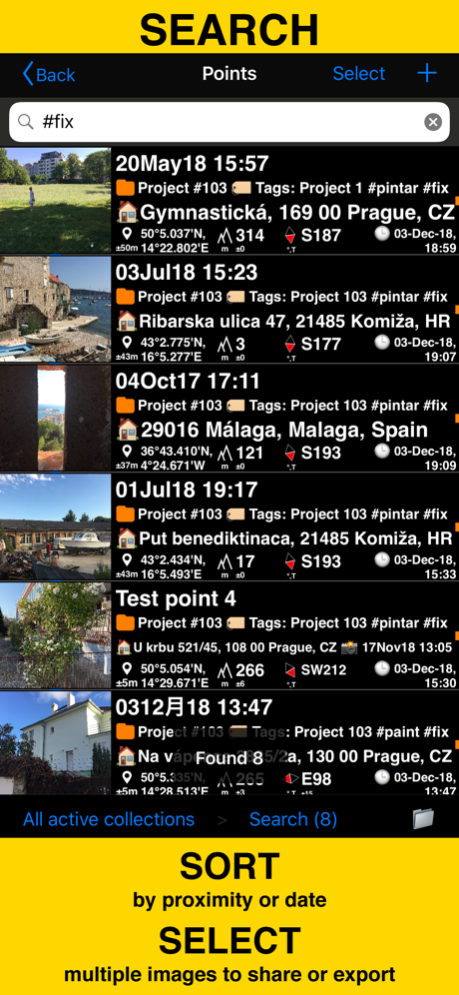
Capture and stamp photos with location, date, address, notes. Add hand drawn annotations. Search & filter your images by title, notes, tags or sort by proximity and date. Organize into collections/folders. Import existing photos from the photo library to restore their location, direction and even notes.
LOCATION OVERLAY
Supports decimal, dm or dms coordinates formats as well as UTM and MGRS.
True or magnetic heading. Degrees or mils.
Accuracy and altitude in either feet or meters.
CAMERA AND CAPTURE SETTINGS
Save photo automatically or open it in preview to annotate before saving.
Option to save copy of the photo to the photo library, either or both original and stamped photo.
ANNOTATE AND COMMENT
Before or after saving the photo you can zoom in/out in the photo preview and draw on the image with your finger or Apple pencil.
Notes overlay for the photo supports Title, Note, Tags/Folder and Address.
Address can be pre-filled automatically based on the photo location or you can manually fill this field.
Timestamp options include many formats and you should always find your preferred languages between them as well.
Scan QR, Bar codes and texts and use scanned content for title or note field in the photo notes editor.
WATERMARK
Pro pack upgrade removes the basic version watermark and allows you to setup a watermark with your own image, text and colors, if needed.
SHARE AND EXCHANGE
Images can be shared with or without their location/notes text and with or without the location/notes overlay.
Saved/shared photo file names can be based on a photo title, note, address, folder/tags field name, folder/collection, coordinates, altitude, heading, capture date.
To transfer points/images in their entirety to another device, use the KMZ (Google Earth archive) export format - this allows to transfer points including images, image notes, annotations, audio notes, to another device.
PDF REPORTS
Generate and share PDF documents for the selected photos/points or whole collection/folder, with options for a number of images per page and photo descriptions.
ORGANIZE, SEARCH & SORT
You can organize images into collections/folders. Existing images/points can be moved between collections.
IMPORT
NAVIGATE
MAP VIEW
== PRO PACK UPGRADE ==
You can do a lot with the basic functions in the app. PRO PACK upgrade adds:
- Ability to create additional point/image collections.
- Enables sharing of more than 5 points/images at once.
- Export/import capabilities. In particular, KMZ export/import enables to transfer collections or selected waypoints between devices.
- Ability to save hand drawn annotations for the image.
- Extra protection of your work and privacy with PIN code or biometric based access options.
- Removes the basic version watermark and allows to apply a custom watermark with your image, text, colors.
Terms of Use: https://www.apple.com/legal/internet-services/itunes/dev/stdeula/
Feb 13, 2024
Version 4.0
• Allows to set a file name pattern for a single file.
• Batch file name pattern can be based on a single file name pattern or can be independent.
• Supported pattern fields are photo title, note, address, folder/tags field name, folder/collection, coordinates, altitude, heading, capture date.
• You can define date/time format for the capture date pattern field, number of leading zeroes in the batch file sequence number, whitespace handling.
* If you decide to keep the default - photo title is used as a photo file name, as always.
◆ Guru Maps added as a turn by turn navigation option for a navigation to a point.
About GPS Camera 55. Field Survey
GPS Camera 55. Field Survey is a free app for iOS published in the Recreation list of apps, part of Home & Hobby.
The company that develops GPS Camera 55. Field Survey is Kalimex-Consulting s.r.o. @Blocoware & Stanislav Dvoychenko. The latest version released by its developer is 4.0.
To install GPS Camera 55. Field Survey on your iOS device, just click the green Continue To App button above to start the installation process. The app is listed on our website since 2024-02-13 and was downloaded 7 times. We have already checked if the download link is safe, however for your own protection we recommend that you scan the downloaded app with your antivirus. Your antivirus may detect the GPS Camera 55. Field Survey as malware if the download link is broken.
How to install GPS Camera 55. Field Survey on your iOS device:
- Click on the Continue To App button on our website. This will redirect you to the App Store.
- Once the GPS Camera 55. Field Survey is shown in the iTunes listing of your iOS device, you can start its download and installation. Tap on the GET button to the right of the app to start downloading it.
- If you are not logged-in the iOS appstore app, you'll be prompted for your your Apple ID and/or password.
- After GPS Camera 55. Field Survey is downloaded, you'll see an INSTALL button to the right. Tap on it to start the actual installation of the iOS app.
- Once installation is finished you can tap on the OPEN button to start it. Its icon will also be added to your device home screen.
